


Severe storms late today into Thursday; high-impact squall line likely tonight
This news announcement is from AEP-Ohio.
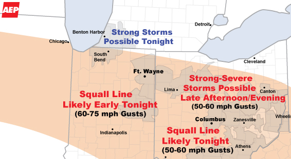
A major severe weather outbreak - including a squall line
tonight - is expected for AEP's East Utilities. The threat area has been
expanded to include all of AEP's East Utilities. Several disturbances
traversing the top of a hot upper-level ridge will trigger the severe
weather.
The first disturbance will cross northern I&M Power early this
afternoon with showers...then probably intensify triggering strong to
severe thunderstorms as it reaches northern and central Ohio late this
afternoon and evening. These storms may produce wind gusts of 50-60 mph, hail
and even a few tornadoes.
A second, stronger disturbance will arrive tonight - likely triggering a
squall line to take shape in Illinois. This squall line is expected to
track through Indiana, Ohio, northern KY and into West Virginia overnight.
While it is not possible to forecast the precise track, timing and
intensity of the squall line - it is likely to produce widespread wind
damage and be a high-impact event for the utilities.
Thursday....severe storms are likely over APCo' eastern service territory and
the entire mid-Atlantic region.

Stories Posted This Week
Monday, July 20, 2026
Sunday, July 19, 2026
Saturday, July 18, 2026
Friday, July 17, 2026
Thursday, July 16, 2026
- Norma Mathews Wilhelm was an elementary school teacher and homemaker
- July 27 blood drive at Ada Community Visiting Nurses
- Alger Public Library BBQ fundraiser tickets on sale
- July 18 Dog Days of Summer event in Kenton
- New communication platform adopted by Ada Schools
- Cancer screening in women: Recommendations, trends, and solutions