























AEP issues severe weather warning

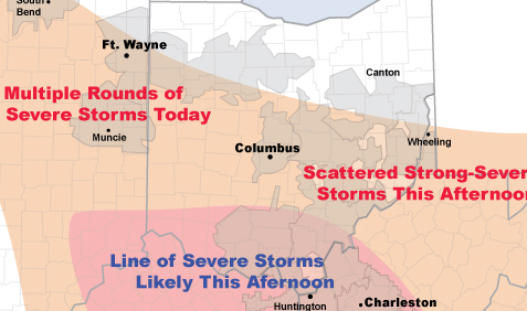
Western Ohio (west areas only)
Multiple Rounds of Strong-Severe Storms
(50-60 mph 9am-3pm)
Severe thunderstorms will impact AEP's East Utilities Tuesday, July 24.
This morning radar showed a line of severe thunderstorms moving southeast through I&M Power. This line of storms was producing wind gusts of 60 m.p.h.
Elsewhere, radar showed numerous showers and non-severe thunderstorms across much of the region.
By late afternoon a more significant line of severe thunderstorms may take shape across southern Ohio. This line of storms would move south across Kentucky Power and APCo producing damaging wind gusts.
If a line of storms does develop a fairly significant outage event could ensue for southern Ohio, Kentucky Power and APCo.