


Weekend forecast calls for more snow and lower temperatures
• Low-Impact Winter Storm Sunday & Monday for AEP’s East Utilities
• Extreme Cold Wave Monday & Tuesday
AEP has issues a weather advisory, which affects the Icon viewing area. Here is the information provided by AEP. The map above relates to this information.
AEP meteorologists expect another low-impact winter storm will track through AEP’s East Utilities on Sunday followed by bitterly cold temperatures and gusty winds Monday.
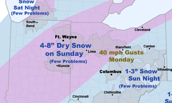
Preliminary information suggests roughly 4-8 inches of dry snow will fall across Indiana and northwest Ohio on Sunday. Over eastern Ohio rain will change to 1-3” of dry snow Sunday night. The precipitation could even start as some light freezing rain Sunday morning over western Virginia (Roanoke),but amounts look negligible. The dry nature of the snow should preclude any significant utility problems.
Bitter cold temperatures and strong west winds will overspread AEP’s East utilities on Monday. Current data suggests the wind speeds will peak near 45 mph, just under problematic thresholds for the utilities.
However, Monday may be the coldest day for AEP Ohio since January, 1994.
Temperatures over western Ohio could remain below 0 F all day Monday. Expect dangerous wind chills of -25F to -40F.
Section: News in