























Forgotten Ada: Why is there a curve on State Route 235 north of Ada

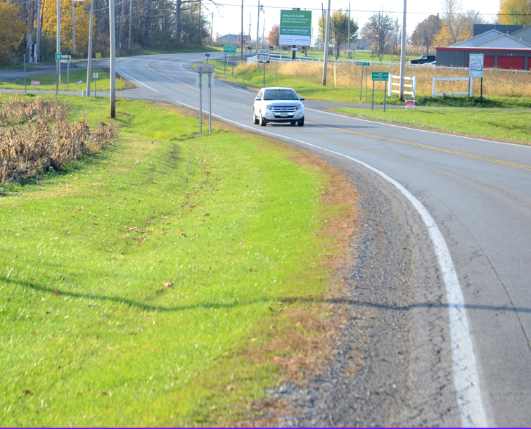
This feature is from Bluffton Icon in a series titled “Forgotten Bluffton.” We edited this feature for Ada Icon and it could easily be titled “Forgotten Ada.”
Why is there a curve on State Route 235 north of Ada near U.S. 30?
Older resident might remember when the curve was a 90-degree jog in the road.
Just north of Bluffton on Bentley Road there’s also a curve in the road, similar to the one on SR 235.
These curves have been modernized by state and county road crews, as once upon a time they were 90-degree jogs.
The simple answer to the question above is that the earth is round and that the early surveyors were trying to run straight lines on a sphere.
The jogs were correction lines. As a result, every six miles the lines going straight north of Bluffton were corrected for the curvature of the earth with the resulting jog.
In the past 35 years as roads were widened and improved the jogs became curves thanks to the various county road departments.
Image driving north from Ada today and coming to an almost complete stop to navigate that jog that is now a curve.
The late Dr. Howard Raid, Bluffton University professor, explained this in greater detail in an essay in “Town at the Fork of the Riley’s.” That booklet was a collection of Bluffton historical stories put into one book in 1961 for the centennial of the Village of Bluffton.
Here’s what Dr. Raid wrote about those road jogs:
If you stop and analyze how you locate a spot on a sphere, you realize that you immediately run into some problems.
While you may run parallel lines one way around a sphere, it is impossible to run them both ways around a sphere and make them very meaningful.
The first attempt to describe property was merely by description. This method is called metes and bounds and is found in Hardin County, primarily south of Ada.
In the Bluffton area, however, with the flat land and relative ease of laying out rectangular surveys a new method was instituted using as a base line certain straight lines. The first one of these is located three miles north of Pandora. At one time this road was known as the “Base Line Road.”
So, the next time you travel north of Ada on State Route 235, remember that originally that curve was a 90-degree bend. And the curve is due to the curvature of the earth.
And, today, it’s simply a part of forgotten Ada.
Stories Posted This Week
Friday, October 16, 2026
Thursday, October 15, 2026
Wednesday, October 14, 2026
- Bluffton Icon headlines, October 14
- Jennifer Della Rae Ritcher, 48, worked in private health care
- David L. Haney, Sr., 76, owned DL Haney and Son Delivery
- Ada FFA students attend Ohio Legislative Leadership Conference
- Ada girls soccer shut out by powerhouse Woodmore
- United Way Black Flame Candle Bourbon Ball, Oct. 17
Tuesday, October 13, 2026
- Bluffton Icon headlines, October 13
- Bulldog boys soccer blanks LCC on Sr. Night
- Bulldog volleyball ends regular season with win vs. McComb
- Union workers at Wilson Sporting Goods stage lunch-hour picketing
- Bulldog girls soccer seeded 2nd
- The Ada history bug bit Lee Crouse in the 1990s
- Polar Bears sports roundup, October 5-11