























Severe thunderstorms headed our way

Here's a weather update from AEP:
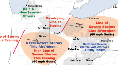
Severe thunderstorms containing damaging wind gusts to 60 mph will threaten portions of AEP Ohio and I&M Power this afternoon into early tonight. A hot, humid, and increasingly unstable air mass is in place over the region. An approaching upper-level disturbance and cold front will trigger the storms.
AEP meteorologists have identified two elevated risk areas:
• Northeast Ohio...primarily from western Ohio across the Canton District. A line of thunderstorms should develop and intensify over western Ohio early this afternoon, then track east. Numerous wind gusts to 60 m.p.h. will be the main threat.
Additional thunderstorms will affect the region through the weekend, however the concern for more severe weather is low.